It is widely recognized that wetlands can provide significant environmental benefits, including assimilation of pollutants, flood water storage, groundwater recharge, carbon sequestration, and fish and wildlife habitat, and that they are threatened with degradation and loss by various stressors including conversion to agriculture and silviculture as well as pressures from encroaching urban and suburban development. Geographically isolated wetlands can provide the same benefits as all wetlands in general and are particularly vulnerable to loss and degradation because they are geographically isolated and have varying amounts of regulatory protection. They may be seasonally or permanently ponded, depending on local conditions. Typically there is a shallow groundwater connection to other wetlands and streams and these wetlands can be sinks for nutrients; thus, alterations (e.g., ditching and drainage, silviculture) can have negative effects on downstream water quality (Amatya et al. 1998). Drainage has impacts on ecological systems, including “direct loss of habitat for wetland-dependent species, significant alteration of biogeochemical and hydrologic cycles, loss of flood storage and water quality functions of wetlands, and elimination of nutrient and sediment sinks and other buffering capacities of wetlands in relation to adjacent upland and riparian ecosystems” (Blann et al. 2009).
The need to increase our understanding of isolated wetland occurrence and ecological benefits is particularly urgent in the context of the rapid development and human migration transforming the coastal areas of North and South Carolina. This study was designed and implemented to meet these needs by (1) developing, testing, and documenting methods that can be used to assess isolated wetland occurrence and ecological significance and (2) applying these methods to characterize isolated wetlands along the North and South Carolina coast.
The Southeast Isolated Wetland Assessment (SEIWA) explored the condition and history of geographically isolated wetlands in an 8-county portion of the coastal plain of North and South Carolina. SEIWA employed a phased approach based on three levels of wetland assessment described by EPA (U.S. EPA, 2006): Level 1, which used geographical information systems (GIS) to identify isolated wetlands in the study area; Level 2, which was a rapid on-the-ground assessment of the type and condition of a random sample of Level 1 sites; and Level 3, detailed field assessments to measure the hydrologic conditions, water quality, and biota (amphibians, macroinvertebrates, and plants) of selected isolated wetland sites.
Geographically isolated wetlands are those that meet the provisions of the US Army Corps of Engineers 1987 Manual, but they have no surface connection to downstream waters via stream, ditch, or continuous wetlands.
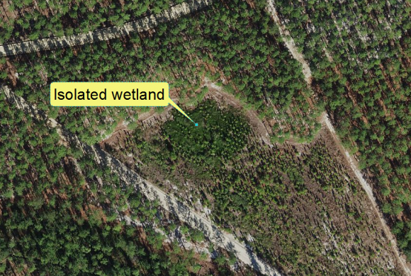
Example of an isolated wetland in North Carolina′s Coastal Plain
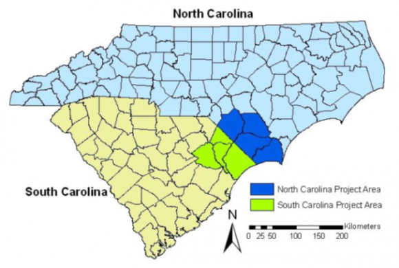
8-county study area
The SEIWA Level 1 GIS approach modeled physical, hydrologic and biological characteristics relevant to geographically isolated wetlands. The Level 1 method produced polygon datasets that represented candidate locations of geographically isolated wetlands for eight counties in coastal North and South Carolina. Level 2 field assessments were then performed on randomly selected candidate isolated wetland sites to determine map accuracy for depicting wetlands and isolated wetlands, as well as to develop an estimate of the characteristics, condition, and relative level of functioning of the target population. In Level 2, we conducted rapid assessments to collect data to evaluate the accuracy of the initial mapping tool and determine the number, extent, relative level of function, condition, water storage capacity, and soil carbon pool of the isolated wetlands in the study area. In terms of accuracy, 69% of the candidate isolated wetland polygons in the study area were wetlands and 22% were isolated wetlands. These accuracy data, along with field results from rapid assessments, were used to estimate the number, size, and condition of isolated wetlands in the entire study area. We estimated there are about 52,000 isolated wetlands in the 8-county study area, with 30,000 in North Carolina and 22,000 in South Carolina. In the study area, isolated wetlands occupied a total of 30,000 acres or about 2% of total wetland area. These isolated wetlands were mostly forested depressions; we estimated they can hold over 4,000 acre-feet of water in North Carolina and sequester around 5 million metric tons of carbon in wetland soils.
In the Level 3 field work, we conducted intensive assessments of selected isolated wetlands in the study area. Data from Level 3 included the pollutant absorption capacity, biological characteristics, water quality, hydrologic connectivity, and cumulative hydrologic effects of isolated wetland clusters, and they created an approach and base dataset that could be built upon with further investigation. A second study (“Part 2”) expanded the Level 3 work through further investigation of hydrological connection, water quality, and biotic communities of isolated wetlands.
The Southeast Isolated Wetland Assessment Project (1) estimated the number and spatial extent of isolated wetlands in a selected study area using GIS mapping tools developed for the project and probability based estimators; (2) developed probability design-based estimates of the number and extent of isolated wetlands and the general of characteristics and condition in the study area; and (3) estimated the assimilative capacity of selected isolated wetlands for key pollutants, hydrologic connectivity, and biotic communities (amphibians, aquatic macroinvertebrates, and plants).
Overall Project Results Summary
Overall, isolated wetlands in our study area are numerous (estimate of 52,000 isolated wetlands in the 8 counties), relatively small (median size of 0.41 acres; mean size of 0.77 acres), and occupy a small percentage of overall wetlands that are on the landscape (about 2% of the total wetland area). The results of this study show that isolated wetlands can store significant amounts of water, show apparent connectivity through groundwater to downslope streams, seem to be acting as sinks for nutrients, metals, and carbon, and generally range in fair to good ecological condition. Isolated wetlands that are in good condition have relatively intact biological communities as compared to other least-disturbed wetlands of similar type. The wetland survey and assessment methods demonstrated in this research project provide some of the technical tools for advancing such further research, as well as for assessing the conditions of isolated wetlands or similar resources in other area. Finally, the maps of candidate isolated wetlands across the study area can serve as a guide to assist wetland regulators and managers in finding isolated wetlands and determining how they may be impacted by surrounding land use.
Notes
- The SEIWA project was conducted by a number of wetland scientists and a statistician in partnership between RTI International, the North Carolina Center for Geographic Information and Analysis, the North Carolina Division of Water Quality (now Division of Water Resources), the University of South Carolina, and the South Carolina Department of Health and Environmental Control.
- This project was funded under a grant from the U.S. EPA’s Regional Environmental Monitoring and Assessment Program (REMAP), U.S. EPA REMAP Cooperative Agreement # COA RM-83340001
Literature Cited
- Amatya, D.M., J.W. Gilliam, R.W. Skaggs, M.E. Lebo, and R.G. Campbell. 1998. Effects of controlled drainage on forest water quality. Journal of Environmental Quality 27:923–935.
- Blann K.L., J.L. Anderson, G.R. Sands, B. Vondracek. 2009. Effects of agricultural drainage on aquatic ecosystems: a review. Critical Reviews in Environmental Science and Technology 39:909-1001.