Hydrologic Connectivity, Water Quality Function, and Biocriteria of Coastal Plain Geographically Isolated Wetlands
“Geographic isolation is often interpreted as functional isolation, especially outside the scientific literature, but this interpretation is incorrect. Geographically isolated wetlands are not hydrologically, biogeochemically, or biologically isolated from other landscape elements or downstream waters.” (Cohen et al. 2016)
The five goals of this study were to: 1) characterize the hydrological groundwater connection between isolated wetlands and streams or non-isolated wetlands; 2) determine whether isolated wetlands absorb pollution; 3) characterize the plant, amphibian, and macroinvertebrate communities in isolated wetlands and develop metrics that indicate site condition and quality; 4) further verify and validate the NC Wetland Assessment Method (NCWAM); and 5) determine the number of isolated wetland acres that have impacted and mitigated for in North Carolina from 2001 to 2011. This three-year collaborative study on isolated wetlands in the coastal plain of North and South Carolina was conducted by scientists from the University of South Carolina and the NC DWR Aquifer Protection Section and Wetland Program Development Unit (both NC DWR groups now dissolved).
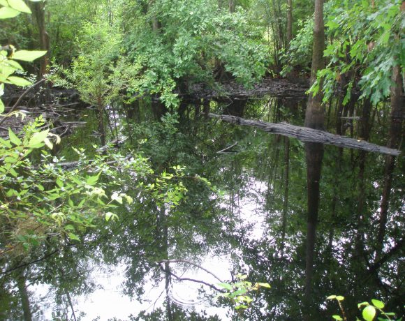 Geographically isolated wetlands appear to have no surface water connection to other water features.
Twenty-two (22) isolated wetland sites in four NC counties (Robeson, Bladen, Columbus, and Brunswick) and four SC counties (Dillon, Marion, Florence, and Horry) were used for this study, the same eight-county study area used in a prior isolated wetland mapping study (SEIWA). Half (11) of the isolated wetlands were assessed for hydrologic connection to downstream waters and half (11) of the isolated wetlands were assessed for biotic communities (plants, amphibians, macroinvertebrates).
Study Findings
Hydrologic Connectivity and Pollution Absorption Study Results
The results of our investigations in North and South Carolina indicated that the study isolated wetlands were well connected to downgradient surface water via groundwater, though the nature of the connection and the ramifications of hydrologic modifications varied due to local variations in the underlying stratigraphy. Any activities that change the dynamics of the system will have a direct impact on upgradient wetlands and downgradient streams and non-isolated wetlands
Isolated wetlands were connected to nearby waterbodies
Groundwater monitoring wells installed between the isolated wetlands and the downgradient streams or non-isolated wetlands were used to study the hydrology and water quality at each study site. Results indicated a definitive groundwater connection between isolated wetlands and nearby downgradient streams and non-isolated wetlands in the landscape.
Monitoring of 83 groundwater wells from 2010 to 2012, three aquifer pumping tests, and water table contour maps clearly showed the 11 study isolated wetlands were hydrologically connected to nearby waterbodies that have surface connection to federally regulated streams. Hydrologic monitoring and drawdown data from aquifer pumping tests indicated that the isolated wetlands were hydraulically connected to the water table aquifer while water table contour maps and hydrologic monitoring showed groundwater flowed toward, and discharged into, downstream connected water bodies.
Isolated wetlands absorb phosphorous, nitrogen, and organic carbon
The isolated wetlands’ capacity to absorb pollution (phosphorus, nitrogen, and organic carbon) was demonstrated by water quality and soil analysis results. Higher levels of nitrogen and organic carbon concentrations occurred in the isolated wetlands than the surrounding upland monitoring wells, which showed these systems have the capacity to sequester these constituents before they flow into the aquifer through groundwater movement. Soil analysis also indicated that phosphorous absorption potential is greater in isolated wetlands than surrounding uplands. Isolated wetlands in the study had high acidity levels and low nutrient levels when compared to connected wetlands.
The combination of groundwater connection and water quality function showed a continuity between isolated wetlands and connected water bodies, indicating that isolated wetlands are an integral part of these hydrologic landscapes. It is qualitatively clear from GIS mapping and hundreds of site visits that the observed geomorphic conditions likely are widespread. The study area landscape is complex in terms of isolated wetland position relative to connected streams, soil characteristics, anthropogenic alteration, and isolated wetland condition, which suggest site specific subtleties influence these functions at a local scale.
Assessment of Biotic Communities
Correlating an Isolated Wetland Index of Biotic Integrity (IBI) with NCWAM
Vegetation metrics that can be used to quantify plant community quality were developed for forested isolated wetlands. The results of this study also further validated and verified NCWAM as a useable rapid assessment tool.
Plant species composition was associated with the defined wetland community type for each isolated wetland – cypress ponds, pocosin, or cypress savannah. Floristic Quality Assessment Index scores indicated all sites were high quality (scores ranged from 16 to 32).
A generalized linear model was used to analyze the relationship between six sets of vegetation IBIs (indices of biotic integrity) (forest, shrub, and emergent IBIs) and NCWAM ratings (overall and habitat function ratings). The results indicated that from one-third to three-quarters of the variation in the IBI(s) were accounted for by NCWAM ratings in the study area. These results also showed that NCWAM could successfully rate the function of isolated wetlands.
Assessment of biotic communities
Unfortunately, metrics to quantify the quality of the biotic communities could not be developed due to unusually dry weather limiting amphibian and aquatic macroinvertebrate communities, but these were still sampled and assessed.
Amphibians and aquatic macroinvertebrates were sampled in 2011 and 2012. Uplands surrounding the isolated wetlands in the study ranged from agricultural lands to natural forest. Abnormally dry and hot climatic conditions in 2011 reduced the number of animals in the wetlands. Additionally, the absence of standing water (year-round at NC sites but seasonal at SC sites), farming in adjacent uplands, and acidic water limited use by amphibian and macroinvertebrate species. Twenty-three different amphibian taxa (Genus level) were collected at the isolated wetland sites, most of which were tolerant of variable environmental conditions (low dissolved oxygen and drying), and diversity at each site ranged from four to nine species. Macroinvertebrate diversity in the isolated wetlands was lower than that generally found in streams and permanent wetlands, most likely due to the seasonal presence/absence of standing water in many isolated wetlands.
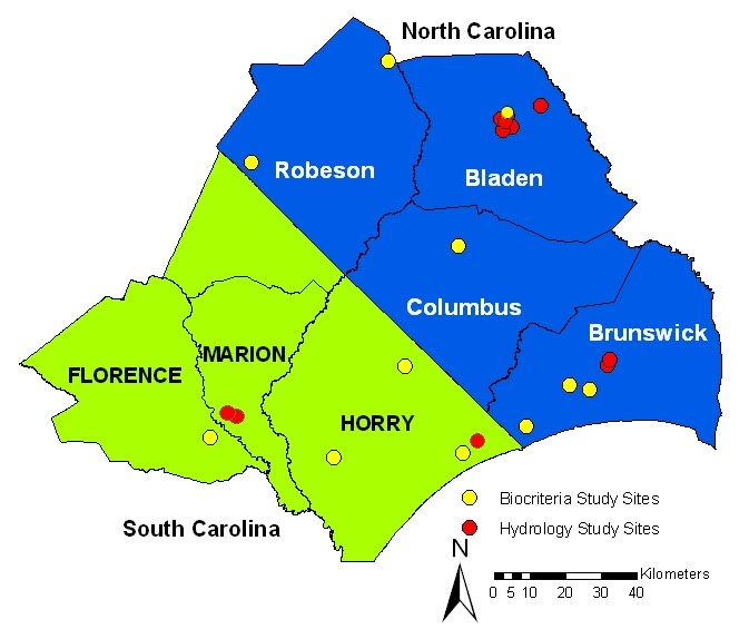 22 isolated wetlands across an 8 county region in North and South Carolina were assessed for this study
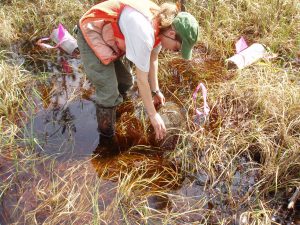
 Soil cores were analyzed as part of the hydrologic assessment study
 Scientists use traps to detect amphibians in isolated wetlands.
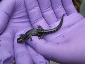 Amphibians can be good indicators of wetland health.
Assessment of Mitigation for Isolated Wetlands in North Carolina
During an approximate 10-year timeline (2001 to 2011), 82.2 acres of isolated wetlands were impacted and reported through the permitting process, and 86.0 acres of wetlands were mitigated, yielding nearly a 1:1 impact to mitigation ratio. However, wetlands used for impact mitigation generally were not isolated wetlands or wetlands with the same habitat conditions that promote the establishment of amphibian communities.
This work was funded under EPA Wetland Program Development Grant Cooperative Agreement CD 95415809 and the North Carolina Division of Water Resources (formerly Division of Water Quality) in collaboration with the University of South Carolina.
Reference
Cohen, M., I. Creed, L. Alexander, N. Basu, A. Calhoun, C. Craft, E. D’Amico, E. DeKeyser, L. Fowler, H. Golden, J. Jawitz, P. Kalla, L. Kirkman, C. Lane, M.Lang, S. Leibowitz, D. Lewis, J. Marton, D. McLaughlin, D. Mushet, H. Raanan-Kiperwas, M. Rains, L. Smith, S. Walls. 2016. Do geographically isolated wetlands influence landscape functions? Proceedings of the National Academy of Sciences. 113(8):1978-1986. DOI: 10.1073/pnas.1512650113