The NC Division of Water Resources Wetland Science and Outreach Team, in coordination with the National Oceanic and Atmospheric Agency (NOAA), will be assessing the accuracy of wetland land cover mapping in the North Carolina mountain ecoregion.
NOAA’s current Coastal Change Analysis Program (C-CAP) mapping is being extended to non-coastal areas across North Carolina, thanks to funding from a variety of sources, including NC DEQ, US EPA, and other agencies in South Carolina and Virginia. This 1-meter high resolution land cover mapping will ultimately be available for the entire state of North Carolina and will be based on aerial imagery from 2020/2021 and other data sources such as topographic mapping (LIDAR), soils mapping, and the US Fish and Wildlife Service’s National Wetland Inventory mapping.
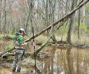
An accuracy assessment will be performed by NC DWR scientists to compare the final C-CAP wetland land cover data to on-the-ground conditions for known wetland features. This accuracy assessment will identify benefits and limitations of the land cover data for wetland identification and management in the mountains of North Carolina.