Download the full 2010 report here —– Download the 2015 published journal article here
(appendices available upon request)
 This project accomplished several goals: (1) collection of additional intensive data for the verification and validation of the North Carolina Wetlands Assessment Method (NCWAM), (2) continued establishment of the NC wetlands monitoring program by collecting data from wetland types previously unstudied by NC Division of Water Resources, and (3) focus of wetland monitoring within certain watersheds to augment watershed plan development by the NC Ecosystem Enhancement Program (now the Division of Mitigation Services).
The project focused on 25 wetland sites of three different wetland types; Small Basin wetlands (12), Bottomland Hardwood Forests (6), and Riverine Swamp Forests (7). Twelve (12) of the wetlands studied were in the Fishing Creek watershed in the northern Piedmont ecoregion of North Carolina, and 13 were in the Lockwood Folly River watershed in the southern Coastal Plain ecoregion. Data were obtained on three intensity levels – Level I (remote GIS spatial analysis), Level II (rapid on-the-ground assessments), and Level III (intensive chemical, physical, and biological surveys). Level I analysis entailed calculation of the Landscape Development Intensity Index (LDI) (Brown and Vivas 2005) for the site’s watershed and a radius of 300 meters around each wetland site. Level II data collection involved two rapid assessments: NCWAM and the Ohio Rapid Assessment Method (ORAM). Level III sampling included detailed chemical (soil chemistry and water quality), physical (hydrology) and biological (amphibians, macroinvertebrates, and plants) data collection.
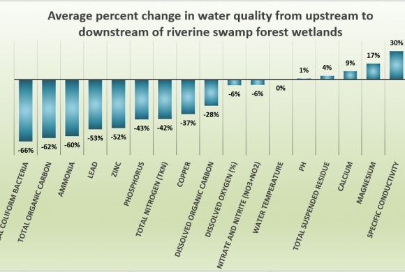
When flowing water was present, water quality data were collected upstream and downstream to assess how water quality changed as it flowed through the wetland system. Riverine Swamp Forests clearly improved water quality while Bottomland Hardwood wetland results were more variable. The Coastal Plain Small Basin wetlands had better water quality than the Piedmont Small Basin wetlands.
Analysis of surrounding upland and wetland soil samples showed that all three wetland types were acting as sinks for nutrients and metals, thereby, improving water quality. Piedmont sites had more pollutants in the soil than Coastal Plain sites. Soils in Bottomland Hardwood Forests were typically mineral while Riverine Swamp Forests contained organic muck. Small Basin wetlands had organic soils with a higher sand content in the Coastal Plain.
Hydroperiods of the three wetland types were variable due in part to differences between the wetland systems and the severe effects of an ongoing drought in the Lockwood Folly River watershed. The hydrology monitoring of Riverine Swamp Forests showed these wetlands were very wet and maintained fairly consistent water levels year-round. Conversely, Bottomland Hardwood Forests were drier during the growing season and were influenced by precipitation and periodic overbank and overland flooding. Small Basin wetlands in the Piedmont tended to stay wetter than Coastal Plain Small Basin wetlands.
 The Coastal Plain Small Basin wetlands had the highest diversity of amphibian species while the Riverine Swamps had the lowest diversity; however, the Piedmont wetlands had the greatest abundance of individuals. Coastal Plain Riverine Swamp vegetation was the most diverse while the Small Basin wetlands in this region had the lowest diversity and a dense shrub layer.
To validate the NCWAM, Level III intensive results were examined in relation to overall NCWAM ratings and subfunction ratings (Water Quality, Hydrology, and Habitat). Additionally, NCWAM results were compared to ORAM scores and GIS Level I analysis (LDI). Significant correlations were found between NCWAM scores and some Level III amphibian and plant metrics, as well as water and soil chemistry results (dissolved oxygen, some nutrients, and metals). Some NCWAM scores correlated with ORAM scores, but not with LDI scores. Correlations between NCWAM Habitat function and the Plant IBIs were of particular interest because this indicated that the habitat subfunction of the NCWAM was assessing the sites appropriately.
The quality and function of the wetlands surveyed in both the Piedmont (Fishing Creek) and Coastal Plain (Lockwood Folly River) watersheds varied due to logging, invasive vegetation, ditching, and buffer impacts. Overall these wetlands appeared to be maintaining their functional water quality and hydrological benefits. Both watersheds had large expanses of open space, although impending development in these watersheds (especially in the Coastal Plain) had the potential to impact these wetlands and stress these systems’ ability to function properly.
This study provided a better understanding of the quality and function of three types of wetlands: Riverine Swamp Forest, Bottomland Hardwood Forest, and Small Basin wetlands. The intensive Level III monitoring results have showed these wetlands are diverse systems comprised of a variety of vegetation in each stratum and providing habitat for numerous amphibian species. Additionally, Riverine Swamp Forests, and to a lesser degree Bottomland Hardwood Forests, can improve water quality by lowering nutrient and metal levels.
Following this study, the NCWAM was adopted by the US Army Corps of Engineers (USACE) to inform their wetland permitting decisions.
Link to the NCWAM Manual and forms
(via USACE RIBITS: 1. Click RIBITS frog icon, 2. Under Filter View – USACE District, click Wilmington from the dropdown menu, 3. Under Menu, click Assessment Tools for available NCWAM manual and tools)